Thursday, May 9, 2013

Conclusion


The most fantastic aspect of Iceland’s physical geography is it’s range of processes and landforms. We see everything from volcanoes to glaciers in one country. Roughly 11% of Iceland is covered by glaciers, and these glaciers feed the many glacial rivers we find throughout the landscape. There are also rills and gullies (smaller streams) covering the island, often spreading in a dendritic pattern, like that of a leaf. Iceland is full of gravitational water, which is water that follows gravity to the water table, creating waterfalls. The island’s incredible amount of ground water (along with the giant glistening glaciers) makes it a beautiful blue wonderland. In the land of ice however, we also find fire. Iceland is home to 35 volcanoes, some of which are still active today. As a result of the eruptive volcanoes, Iceland is covered in flood basalts. Flood basalts are large stretches of land covered by basalt lava that poured over the landscape after an eruption. Another aspect that is unique to Iceland’s geography is it’s high latitude. The island sits just below the Arctic Circle, making it the perfect environment to see the aurora borealis (a “light show” in the sky due to solar radiation interacting with oxygen and nitrogen in the atmosphere). Iceland is ultimately a beautiful and unique environment.

In 1,000 years Iceland may look different:

Geologically speaking, Iceland is a very young island, at only 20 million years old. In 1,000 years, I do not think that Iceland will change significantly because geological processes take so long to occur. I do believe that because Iceland is a volcanic island, it may grow bigger in the coming years. Iceland is situated on a “hotspot” which is a narrow upwelling of magma from the earth’s core, as the magma rises and cools it creates more land mass. Also, is any of Iceland’s volcanoes were to erupt in the next 1,000 years the lava flows would harden and become new land. Scientist know that one of Iceland’s biggest volcanoes, Hekla, has erupted at least 20 times in the last 1,000,000 years.
 
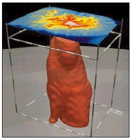
                      Three dimensional view of the mantle plume under Iceland.
 
 
In 10,000 years:
Iceland is cut almost directly in half by the mid-Atlantic ridge. This ridge is exists because the Eurasian and North American tectonic plates are diverging (pulling away) from one another. As the plates move Iceland moves with them. In 10,000 years, Iceland may very well split do to the ridges diverging. Scientists have already found rifts in Iceland that are occurring along the ridge. The portion of the Earth’s crust located between the two rift zones, called Hreppar in South Iceland, is departing from the North American plate.
 
                                This picture shows the mid Atlantic ridge cutting through Iceland
                                                            along with the location of its hotspot.
 
In 1,000,000 years:
I believe that in 1,000,000 years, Iceland will have split due to the spreading of the plates creating two islands. Though the hotspot that created Iceland may be fixed, the plates are constantly moving. I believe that as the plates move over the hotspot, a string of islands may be created similar to the Hawaiian islands. Though in 1,000,000 years, it may only be the very beginnings of this island chain because 1,000,000 years is still a short period of time in geography.
                           This image depicts the active rift zone that are currently in Iceland.
                     http://academic.emporia.edu/aberjame/student/brown3/iceland.htm
 
In Conclusion: Iceland is changing every day and may be more than one island in the future. I believe it's beauty and unique geography will attract people for many years to come.
 
SOURCES:
http://www.foxnews.com/scitech/2011/07/06/iceland-volcano-to-erupt-again-experts-say/


Wednesday, April 17, 2013


The Atmosphere of Iceland

One of the most fantastic natural phenomenon, the aurora borealis (also known as the Northern Lights), occur high up in the earth’s atmosphere. Lucky observers can watch a spectacular light show in the sky, with vibrant colors seemingly dancing with the stars. The aurora borealis surrounds the north magnetic pole, and they can be seen in Iceland in September through March, on clear nights. The auroras are caused by highly charged electrons from solar wind (“streams” of energy released from the sun) interacting with elements in the atmosphere. Solar wind streams off of the sun at up to one million miles per hour, and it takes nearly forty hours for it to reach the Earth. When they finally do reach our planet, the energy flows along the magnetic lines of force that surround the Earth, that radiate from it’s core. As the wind flows through the magnetosphere (which is a highly charged electrical area), it interacts with two specific elements of the Earth’s atmosphere, Oxygen and Nitrogen.  These interactions can occur very high in the atmosphere, nearly two hundred miles from the surface, but they can also start at only twenty miles above the surface.  The color that is created by this interaction, is dependent upon what element the solar wind is hitting, and at what altitude the interaction is taking place. For several months of the year, you can see the aurora borealis from the island of Iceland. Iceland uses this amazing optical phenomenon as a tactic for drawing tourists in to visit the country.

  •  Green - oxygen, up to 150 miles in altitude
  • Red - oxygen, above 150 miles in altitude
  • Blue - nitrogen, up to 60 miles in altitude
  • Purple/violet - nitrogen, above 60 miles in altitude


Here, in Iceland, we can see the sun in the sky, along with a green hue of the borealis. This color is caused by oxygen reactions with solar wind.


http://travel.nationalgeographic.com/wallpaper/travel/photo-of-the-week/iceland-aurora-borealis/
Here in Iceland, we can see a snow covered area, and an amazing mix of all of the aurora colors: green, blue, purple, and red.


Resources:


Sunday, March 10, 2013

Hydrology in Iceland

Iceland is prominently made up of a central volcanic plateau, and it is ringed by mountains. Nearly 1/9 of the country is covered by lava fields, while another 1/8 is covered by glaciers. Since this landscape is so controversial in elevation, it has a high drainage density. When water flows over the land only a small amount is absorbed, while the rest drains into the drainage basin (flatlands) where rivers and streams are created. This impermeable and non-porous surface mixed with the elevational patterns of the country make it a perfect landscape for radial drainage patterns. We also refer to this type of landscape as a weather-limited landscape, where any particles are easily transported by overland flow and can be redeposited elsewhere.

(Here we see an enlargement of one particular part of a glaciated area of Iceland. We can see 3 glaciers and the surrounding mountainous area that gives iceland such a controversial landscape) 
         http://www.bgs.ac.uk/research/glacierMonitoring/home.html
 

 Waterfalls are abundant in Iceland due to a process called overland flow. When there is more water on the surface of the land than can be absorbed into the ground, it can lead to the creation of waterfalls, big and small. This water is known as gravitational water, as it moves with gravity to the water table.
(Here we see the Hvita waterfall in Western Iceland. We can see that the gravitational water is flowing downhill and there is too much to be absorbed by the land, creating overland flow.)
http://iceland.vefur.is/photogalleries/Icelandic_waterfalls/


One type of river found in Iceland is a glacial river. These glacial rivers are created by drainage from the glaciers. As the water flows over the land it creates rills and gullies, and they tend to divide into numerous tributaries that have a dendritic pattern, like the veins of a leaf. One amazing form that can be found only in glaciated areas of the world like Iceland are called sandurs. A sandur (or outwash plain) is formed by glacial sediments deposited by the meltwater of glaciers. Glaciers are full of silt and sediment that they have aquired as they slowly move across areas of land. Water that is melting and running off from the glaciers (glacial rivers) can carry much of this debris away, often depositing it in a large plain, known as a sandur.


 (Here we see the Tungna River in Iceland, you can easily make out the dendritic pattern of the water, as it spreads out into veins)
http://trivoxphoto.photoshelter.com/image/I0000VhdXAeVJBhg


(Skafourwash sandur in Iceland. Here we can see the water flow patterns and the left behind debris that was carried from the glacier.) http://www.visualphotos.com/image/2x4741260/iceland_skafourwash_sandur


SOURCES:
http://www.nationsencyclopedia.com/geography/Congo-Democratic-Republic-of-the-to-India/Iceland.html
http://clasfaculty.ucdenver.edu/callen/1202/Battle/Destroy/Wx/Weathering/WeatherLimDefine.jpg
http://en.wikipedia.org/wiki/Outwash_plain
http://www.eusoils.jrc.ec.europa.eu/library/maps/Circumpolar/.../136.pdf

Monday, February 18, 2013

Volcanism in Iceland

The island of Iceland credits it's existence to volcanism. Iceland was formed by a large volcanic hotspot that sits on the Mid-Atlantic ridge, which is a divergent boundary. This plate boundary between the North American and Eurasian tectonic plates runs north and south beneath the island of Iceland. Throughout Earth's history, the two plates have been pulling away from one another, allowing magma to find weak spots in the lithosphere and make its way to the surface of the Earth's crust, where it turns into lava. This lava hardens and becomes new crust. As this process continues, the island slowly grows, about 2.5 centimeters every year, although some parts grow nearly 9 centimeters per year.

{The Mid-Atlantic Ridge passes directly through Iceland, crediting it's creation and volcanism.}

In 2010, one if Icelands many large volcanos, Eyjafjallajökull, erupted without warning. The eruption came after nearly two centuries of the composite volcano being dormant. Lava flows and falls, "fire fountains," and ash were spewing from the volcano in a spectacular but scary show. Most of Europe became ash-covered and it stranded millions of people in airports, as the eruption made the sky above the Atlantic a no-fly zone. Many citizens were evacuated, as hot remnants were ejected from the volcano. Now, many scientists believe that Iceland is a ticking time bomb and we could expect another eruption at any time. Three giant volcanos; Katla,  Hekla, and Laki have begun to swell and grumble so to say, and the experts say that the eruption from any of these volcanos could likely cause global famine and even a shift in the climate.


                                         {The Eyjafjallajökull volcano erutption of 2010.}
                     http://www.boston.com/bigpicture/2010/04/more_from_eyjafjallajokull.html


                                               {Katla volcano in Southern Iceland}
http://geographyblog.eu/wp/iceland%E2%80%99s-scientists-say-activity-at-katla-volcano-increasing-next-eruption-could-be-huge/

The two largest flood basalt events in historic time have been in Iceland, and one was due to the Katla volcano system, at Eldgjá. A flood basalt is the result of an eruption or series of eruptions that spill basalt lava over stretches of land.


                                                    {Flood Basalt at Eldgjá}
                                             http://www.addax.se/iceland/highlands.html

SOURCES
http://topics.nytimes.com/top/news/international/countriesandterritories/iceland/eyjafjallajokull/index.html
http://www.pbs.org/wgbh/nova/earth/doomsday-volcanoes.html
http://www.nat.is/travelguideeng/geology_volcanism.htm

Sunday, January 27, 2013

Introduction:
My name is Kirbie Williams. I am a student at UC Denver. I am in my 3rd year of college, and I am a History major and a Geography minor. I grew up in Nevada and have been living in Denver for about 3 years. This blog will focus on many aspects of the geography of Iceland. I have chosen Iceland because when I look back on the geography classes I have taken in my college career, I cannot say I know much of anything about the island of Iceland. I am excited to learn about this subject, and I hope to dig deep into the geography of my chosen landscape.